| Main Page -> Maps (3) -> Mallet - Source of the Nile |
|
|
A higher resolution scan of the map. - 2169013 bytes
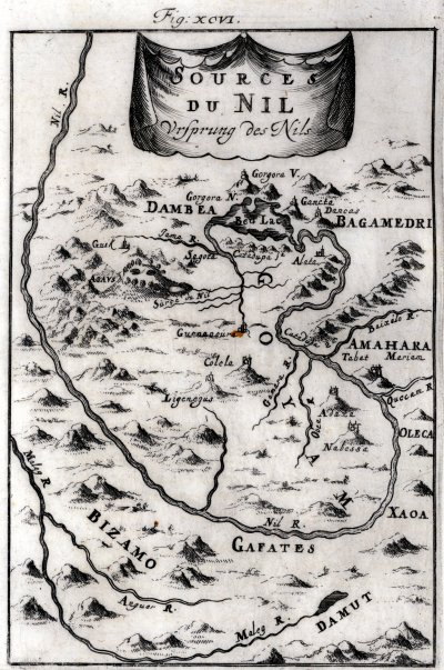
Sources of the Nile
This is a relatively accurate map of modern day Ethiopia. Considering that the majority of the interior of Africa was unknown by Europeans until the 19th century, this map portrays a fairly accurate representation of the area. But then again, this specific map is not really that surprising considering that Europeans were acting as missionaries and traveling through this area at least a century prior to the printing of this map.
The primary river in the map is the Blue Nile (also known as the Abbay or Abay river). It is not possible for me to ascertain accuracy of the cities on this map (as I do not have sufficiently detailed modern maps of this area) but the rivers strike me as remarkably accurate considering the probable description that Mallet had to work from. The Maleg (Didessa) River actually joins the Nile (Abay) River before it (the Nile) turns north. It still may not join in the area of this map as the Nile flows more to the west before turning north. (These details are difficult to ascertain in the satellite imagery.)
I am not sure why Mallet used the "R" abbreviation ("Nil R.") instead of the as opposed to the French "Fl.". I think it may provide some insight into his sources for the engraving.
The mountains in this map seem to be largely for purposes of filling space in what would be largely unknown to Mallet. Let me state that I do not know the source that Mallet used, but I think it is safe to assume that he relied upon descriptive accounts of others travels rather than actual surveys that are clearly evident in his other maps.
| Map | Modern place name | |
|---|---|---|
| Dambea | Dembiya | |
| Bed Lac | Lake Tana | |
| Bagamedri | Begemder (Closely matches name and location) | |
| Goyam | Gojjam | |
| Amahara | Amhara | |
| Nil R. | This is the Blue Nile. It is also called the Abay River in Ethiopia. | |
| Maleg R. | This is most likely the Didessa River. | |
| Anguer R. | Hanger River | |
| Damut | Damot |