| Main Page -> Maps (3) -> Mallet - New Continent |

|
A higher resolution scan of the map. - 2061698 bytes
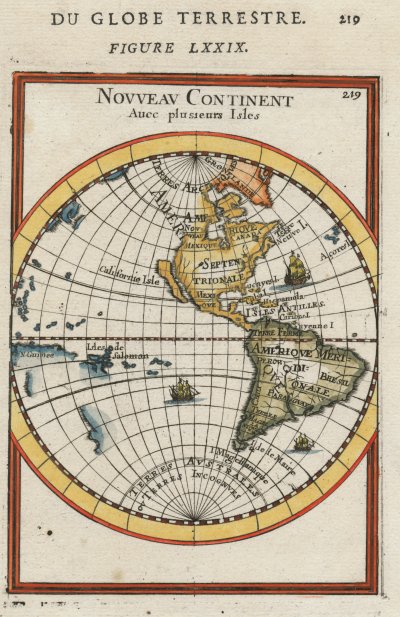
NOVVEAV CONTINENT
Auec plusieurs Isles
NEW CONTINENT
With many Islands
California as an Island
Between the stereographic projection Mallet used and his reduced size of the Pacific and Atlantic oceans I am only able to contrast North and South America with the engraving. An entire hemisphere simply cannot be displayed at this scale and size in Google maps.
The major feature of interest is the representation of California as an Island. This map was published during the 100 or so years that California was thought to be an Island. Mallet doubly confirms the error by "closing out" the top of the Island and then labeling it as such.
Also of interest are the errors of space that were mentioned previously. The scale of cross-ocean distances is off by a significant amount. For example, the eastern coast of New Guinea is actually over 90 degrees west of Baja California and over 105 degrees west of Mexico's inner coast. Using Mallet's meridians (of 10 degrees each) I measure approximately 40 degrees from the coast of California Island to the east coast of New Guinea on his map. A proper projection of a map centered on the inner coast of Mexico would show lots of emptiness at this scale west of the Americas. The situation east is not much better with the Azores Islands being off by about 10 degrees as well.
Reliably determining longitude to the accuracy noted here would remain a technical hurdle for at least another hundred years. Those interested in this subject should read about the clock maker John Harrison and his quest to solve this problem.
I would like to add that I was so eager to get a California as an Island map that I broke my more recent purchasing rule that I do not buy maps or prints with modern coloring. No matter how poorly I present it here, it is a historic artifact not a coloring book page. This is an item that pre-dates me by about 300 years and I hope that it continues on long after that. The thought of impressing a coloring scheme over the engravers / publishers original intent is a bit arrogant and certainly afoul of proper archival methods. Imagine if the archivists at the Smithsonian decided to add some modern changes to various items to increase public interest.