| Main Page -> Maps -> Tassin - Castres |
|
|

|
A higher resolution scan of the map. - 392188 bytes
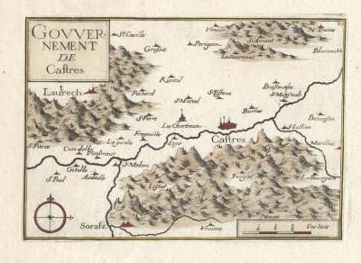
Govvernement de Caftres
This is a 1638 map of Caftres (Castres) in the Languedoc reigon (Tarn département in Midi-Pyrénées Region) of France. It depicts the area along the Agout river.
Some of the place names are:
Nicholas Tassin was an engraver out of Paris who specialized in small maps of this style. He was active from 1633 to 1655.
I do not have a publication for the date of 1638 for Tassin but do have a date of 1638 for a publication by Tavernier that Tassin (as well as others) contributed to. My ability to trace the source ends here.
My (limited) sources of information on Tassin: