| Main Page -> Maps -> Ortelius - Burgundy France |
|
|
|
A higher resolution scan of the map. - 2290491 bytes
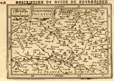
Description Dv Dvche De Bovrgoigne
Burgundia Ducatus
This is a 16th century map from the Bourgogne region in France. The Google supplied satellite imagery is not helpful as the orientation is different and the satellite imagery is not detailed in this area. (Zooming out in the Google map may help see generally where this is.)
It is easiest to locate this area on modern maps by looking for the city of Dijon (labeled as Dyon) in the Bourgogne region of France. It is centered on Arnay-le-Doc France between the Saonne and Loire rivers. Heading "down" on this map will soon lead to Switzerland. This map is approximately equidistant from the Belgium border on the "right" and the Mediterranean Sea on the "left".
I do not understand the scale markings on the borders of this map. Map makers often used different prime meridians so I can understand the right and left values not agreeing with modern values. The latitude (top and bottom scales) is off by about 10° from modern usage. If it is a mistake (unlikely) or a different means of measuring (my current belief) I do not know.
Abraham Ortelius (Ortel) (1528 - 1598) is known for creating the first collection of maps as an atlas that he called the Theatrum Orbis Terrarum (Theater of the World).