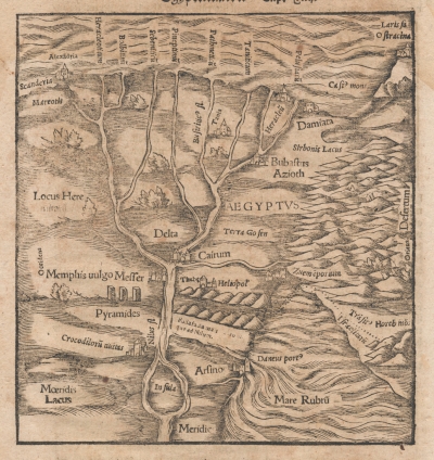
| Main Page -> Maps -> Sebastian Munster - Egypt |
|
|

|
A higher resolution scan of the map. - 750670 bytes
| Map Name | English/Modern/Actual Name | Notes |
| Pyramides | Giza (?) | I find this the most interesting part of the entire map. The pyramids are drawn as "blocks" rather than the actual pyramid shape. Because of the number and location I suspect that they are meant to be those of Giza. |
| Memphis uulgo Meffer | Memphis | |
| Arfino | Arsinoe | Near modern Al-Fayyum this was closer to Moeridis Lacus (Lake Moeris) and Crocodiloyuauitas (Crocodilopolis (spelling in the print is somewhat unclear)) that were on the west side of the Nile, rather than on the Red Sea as seen in the print. Here a shrine was built to the crocodile god Sebek (Sobek and Suchus are amongst the many spellings). |
| AEGYPTVS | Egypt | A variation on the Greek name for Egypt |
| Cairum | Cairo | At the time of this printing Cairo was one of the largest cities in the world. |
| Alexãdria | Alexandria | |
| Damiata | Damietta | |
| Bubaftus | Bilbais | |
| Heliopol | ? | This could possibly be Heliopolis, but would be off by nearly 200 miles. |
| Thebe | Thebes | (If this is actually Thebes) This is off significantly as it would be over 400 miles south at Luxor. |
Sebastian Münster (1489 - 1552) was a German mathematician and linguist at the University of Heidelberg, and from 1529, at the University of Basle. He is known primarily for two works, Cosmographia and (an edition of Ptolemy's) Geographia.
The Cosmographia was first published in 1544 consisting mainly of woodcut prints. It would be re-issued in multiple languages and versions for nearly a century by his step-son Henri Petri (last Petri version was in 1628). Many of the later versions substituted copper-plate engravings for the earlier woodcuts.
Many of the woodcuts and engravings from these works are commonly attributed to Münster although a significant number were by others who contributed throughout the various versions.